Life has a way of rooting you in. Even the most adventure-oriented soul sometimes gets a taste of sweet domesticity and, aided by the annual getting-older process, the feel of wind against your cheeks gives way to the feel of a freshly laundered pillow case at 9 AM on a Saturday.
The travelers: Me, 38, newly re-married, still recovering from a rough-and-tumble summer of work in the field doing botany stuff, a lifelong Oregonian who still has very little sense of what lies east of the Cascades. Eleanor, 41, also married, professional school counselor, trail-obsessed ultra-runner with luddite tendencies. Juju, 5, dog, 1.25 years into a career change from backyard ball-hound to off-leash field assistant, wildlife aficionado.
Eleanor and I have been adventuring together nearly a decade now. Through career and life changes we’ve always found a way to escape into nature to take deep breaths, whether through midweek trail runs at the crack of dawn or backpack adventures that bring us a little closer to our found home in the Rogue Valley. Longer trips, planned over the course of several weeks, provide a light at the end of tough days.
Eleanor’s current schedule dictates that adventures of the multi-day kind must happen on holiday breaks, and summer is my busy season, so these last couple of years my bestie and I have committed ourselves to the art of winter camp-outs. In 2022, we headed for the redwoods of northern California, and experienced two breathtakingly frigid nights beneath the stars. We also learned the best thing about winter camping: Even the busiest sites (the trail we chose was trampled wide by hundreds of warm-season tree-gazers) can be enjoyed in silence and solitude as the solstice nears. Also, there’s no better time to get close to a good book then after that timid sun goes down at 4:30, snuggled deep in your many layers of clothing and sleeping bag.
Last spring, I experienced a fascinating work trip climbing steep hills in the Hells Canyon region, just over the Oregon border in Idaho. The landscape there is unlike any I’ve seen; the treeless, ancient hills look like they’ve been molded by sentient hands into shapes just short of familiar.
While camping and working in the canyons for a week, I heard it repeated by locals that the area is known as the “Banana Belt” of Idaho because it stays warmer there in winter than anywhere else. That’s probably when the seed got planted to go back. This fall, when doing “research” for our Solstice trip, I found and immediately booked a beautiful little cabin perched on the west side of the canyon just above the tiny town of White Bird. We can always cancel it, I told Eleanor, but it looks incredible. She countered that the cabin was a 10-hour drive away, across an inhospitable wasteland. Well, she didn’t put it that way, but she was skeptical. I convinced her. The husbands were informed. Then it was just a matter of counting down ’til winter break.

Day 1, 12/17: Bugging out.
7 AM, 28 degrees. Sleepy goodbyes to humans and dogs not invited, and Eleanor and I pile our gear into my Subaru, Ruby. Juju stretches out in the backseat, hanging her head over the edge of her dog hammock to watch me drive.
Leaving the Rogue Valley in the rearview, we head up and over the Cascades, the famed mountain range that defines the eastern border of our daily lives. A pit stop at Lake of the Woods to tap our toes on the thin ice of the shoreline, and then we point the headlights downhill again, into the Klamath River basin. Eleanor pulls out her atlas and my copy of Roadside Geology of Oregon, which we will reference almost constantly for the rest of the road trip, grounding ourselves in place as well as time as we speed across the desert.
South of Bend, we take a car break to scramble around on frost-covered chunks of lava rock, spewed a few thousand years ago by the Newberry Volcano, a sleeping giant that sits beneath 1,200 square miles of central Oregon. Our insignificance in the face of geologic time now firmly established, we pile back in and continue the journey east.
Fro-yo sidebar: It’s hard to know what to pack on a winter adventure. The only thing to count on is that the weather may change at any moment, and that the one piece of equipment you leave at home will be the one you need. I err on the side of over-preparation: All of my long underwear went in my pack, along with snow pants and my warmest winter hat. I’m wearing a significant number of these toasty layers as we cruise through Bend, and the temperature climbs to 50 degrees. It’s lunchtime so we pull into a strip mall offering health-tastic bowls as well as frozen yogurt. What the heck, I’m on vacation, it’s winter break, and I’m sweating. I sit in the sun and spoon sweet frozen dairy while Eleanor waits on a more wholesome meal.
Next we cross a juniper-sagebrush landscape described on the map as a military training ground. In the distance to the northwest, Smith Rocks loom like a gateway. Joining up with the east-west superhighway of Oregon, Highway 26, we cruise through Prineville and skirt along the southern edge of John Day Fossil Beds National Monument. If we were to detour north we would see the Painted Hills, formed by eons of volcanic activity and sediment deposition. Sticking to the route as planned, we do see some distinctive, colorful striping on the roadside, as well as many other curious formations as we wind our way through the canyons.
At 3:30 pm, we roll into our campsite in the Malheur National Forest, south of Highway 26, near the Strawberry Mountains. As we set up our tents in one of the two unoccupied sites along a creek, just one vehicle rattles by us on the forest road: A truck with a Christmas tree in the back. An hour later, as darkness settles, we roast weenies, drown them in sauerkraut and mustard, and sit back to wait for bedtime.
Sitting doesn’t suit me. Instead, I decide to face my old fear of the dark and walk down the road with Juju. The trees are too thick here to see much of the starry sky I’ve been craving.
Lit by a half-moon, the road takes me over the little creek to a rocky outcropping. Perfect. Juju leads the way as we scramble up to the top. Here on a cushion of moss, I can see the firelight, enjoyed by Eleanor, flickering off the trees surrounding our little camp. Everywhere else, moonlight and solitude. Directly above and on forever, stars.
[Break for Photos]


Day 2: White Biiiiiiird
8 AM, 36 degrees, we are taking in the sunrise at a local graveyard. Death and dying happen to be Eleanor’s professional specialities; cemeteries to her are like bookstores to the writer. I climb the hill above the small fenced-in plot, less interested in headstones than landscapes. Juju is interested in the birds nesting in a clump of shrubs, and the evidence of cows on the hillside.
Evidence of cow is everywhere out here. Where there may be a blade of grass in an acre of land, there is a cow to find it, and tall stacks of hay bales tower over ranch dwellings like prairie skyscrapers.
The small town of John Day provides an espresso pit-stop, and we’re ready to take on some serious miles. First, over the Blue Mountains covered in big trees and snow, ten degrees colder than the valley floor. I experience the first chilly breeze of the trip – ah, now we’re roughing it! Then the Ochocos — dry and deserted. Blue skies and big winds on high passes. Big views of the surrounding mountain ranges, which we allow ourselves the luxury of viewing through the windows of the car. We need to make time if we are to make White Bird by sunset.
Things flatten out from here. We say goodbye to Highway 26 and cruise into Ontario, Oregon for lunch, crossing the Malheur River on the way. Then it’s north toward Idaho and Hell’s Canyon, following the Snake River and Highway 95.
The canyon walls are steep and thickly forested, making the road dark. It’s like someone ran the clock ahead and it’s suddenly an hour later. Oh wait, we crossed a time zone — it actually is an hour later. Snow in this canyon means a quick break to crunch around with the dog.
We’re in the final stretch, and I take over driving. The canyon widens a bit, and the trees thin out. Now it’s starting to look like Hell’s Canyon; steep, grassy hills that stretch toward the sky, sculpted by water and wind.
Our cabin is situated near the top of one of those hills, above the tiny town of White Bird. It’s a four-mile haul up the gravel switchbacks, and we see its twinkling lights from far below. Ruby feels suddenly like a cartoon car chugging back, forth, and up toward its destination, cooped-up passengers hanging out the windows. It’s still warm outside. In the distance, snow-capped mountains.
Day 3: Snake River
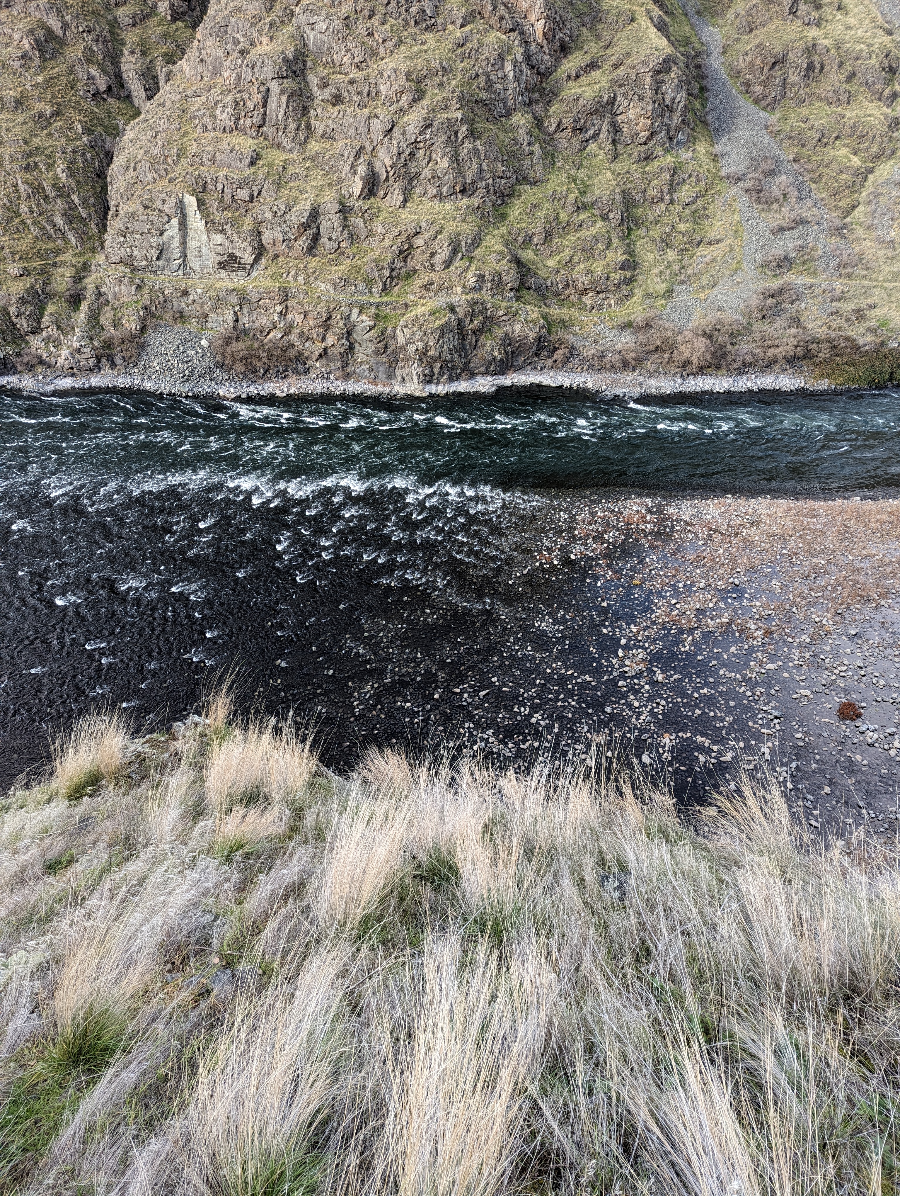
The Hells Canyon National Recreation Area encompasses 650,000 acres of canyon carved by the Snake River, which also happens to form the border between Oregon and Idaho. These public lands are bordered by huge private ranches. Our cabin is about 17 miles from the Recreation Area and freedom to roam. As comfortable as it is, with panoramic views of the Little Salmon River canyon (not to mention the wi-fi), the three of us are up before the sun ready to finally go for a decent hike.
Ruby faithfully takes on the windy forest road, one of only three that enter the Hells Canyon NRA. At the top of the ridge between the two canyons (Snake/Hells and Little Salmon River), there’s a pullout to allow travelers to take in the view. It is jaw-dropping: Hells Canyon must have earned its name by being the deepest river canyon in North America. Viewpoint elevation: 4200’. Temperature: 36 degrees. There’s snow on the ground, but the road is clear all the way down to the Snake River.
“Great, now I don’t need to go to the Grand Canyon,” says Eleanor. Hells is deeper. You just have to share it with a few cows.
A gang of friendly bovines welcomes us to the parking area for the Snake River Trail, where there is just one other vehicle. This trail extends 30 miles downstream/south, a tantalizing journey that we won’t be able to complete in this trip. But we are grateful to be out on a sunny, breezy day, water and lunch in my daypack.
The trail climbs over rocky outcroppings, winds up side-canyons, and crosses prairie bluffs dotted with bunchgrasses. We note skeletons of last spring’s wildflowers and conclude that it must be a stunning show: Wild sunflower, biscuitroot, cinquefoil, milkweed, lupines. Live winter plants also put on a show: Bright yellow and red stems of willow and dogwood in the creeks carving the side canyons, intriguing yellow bunches of berries we later learn belong to poison ivy, vibrant lichens graffitiing giant boulders. Close to the Snake River, the occasional ponderosa pine grows straight, tall and grey-green, or lives a second life as a silvery snag. And we take every opportunity to gaze straight down from cliffsides into the the turquoise water, now slate-grey, now reflecting the ochre hills or sky-blue. Eleanor, who has an eagle-eye for wildlife, spots an otter 100 feet below us scampering over boulders, oblivious to our presence.
We turn back at mile 4; the temperature has climbed to 60 degrees and once again I’m sweaty in too many layers. The Banana Belt is real.
That night, we feast in White Bird on burgers, salad, and smashed Idaho potatoes smothered in gravy, sharing the small diner with three other customers, obviously locals.
“What brings you to White Bird?” asks our waitress. The rafting season is over.
“Just exploring,” we tell her. She shrugs.
Day 4: Character-building
After Hell’s Canyon, our next destination is Steens Mountain. It’s a 6-hour drive south and west, near the Oregon-Nevada border.
The drive involves a little backtracking down Highway 95. We stop in the Little Salmon rafting hub of Riggins, this time for espresso drinks, and find the Two Rivers Roasters to be surprisingly excellent. North of Ontario, we once again find ourselves in thick fog, but a notable glimpse through the mists was to Zim’s Hot Springs, which is run by the Grand Ronde tribe, original inhabitants of these lands. I saved it for my next trip out with husband, who is a hot springs aficionado like me. Eleanor would rather have a bucket of sand dumped over her head.
Past Ontario we rejoin the Malheur River and follow it along Highway 20, which traces between gentle hills and reveals basalt flows in roadcuts. The same basalt that’s in the Columbia Gorge and also formed Steens Mountain, according to the Roadside Geology. The thought of molten rock spanning such a distance — half the state, it seems — is a bit mind-boggling. It also makes me worry about water.
Six years ago, I took a little bicycle journey from southern Oregon, through the Klamath Basin to the Strawberry Mountains. In my original vision of the route, I hoped to ride due east and visit Steens Mountain before meeting the path of the 2017 total solar eclipse near John Day. But I ran into a big logistical challenge, especially since the eclipse happened in August: There’s no water for the last 72 miles west of the Steens. It’s also mostly gravel road through sagebrush.
This time, of course, Ruby can carry as much water as we care to drink, so we stop at a small diner to fill up our flasks. Soon after this, the route turns to a gravel road, winding through the Diamond caldera (all lava chunks, no diamonds), before meeting up with Highway 205, which takes us into Steens Mountain by midafternoon.
Steens Mountain is a unique formation that looks like an entire mountain range from a distance, but is in fact one block of earth that was uplifted by the movement of tectonic plates and sits at an angle to the flat desert. When approaching from the northwest, as we did, the fact that you’re approaching a mountain is not evident; the land rises gradually over a 20-mile distance to reach the peak, then drops abruptly for one mile (5,280 feet) to the desert below. We weren’t able to go up to the summit (there is a road, but it was closed for winter), but I imagine that it looks a bit like the edge of the earth.
When we arrive at our campsite at Page Springs, the lowest-elevation campground at Steens (4,200’ above sea level, and also the only one open in winter), my first observation is that it’s fricking cold. The sky is clear blue and the sun is just about ready to disappear behind a rim of rock. Eleanor can’t get over the fact that the campsites here are quite spacious — we love visiting the Oregon coast, but three Sunset Bay campsites would fit inside our one. There is one other party camping at another site, otherwise we have the place to ourselves. The water spigots are off as expected, but the pit toilets are clean. When filling out the form for our $16 site payment, under the line for “Reason for Visit”, I put down “Character Building”.
The rest of our evening is absorbed by setting up camp, building a fire, and drinking hot toddies to stay warm. Juju breaks out the new Carhartt dog jacket gifted by her dad before the trip. That night, it drops to 25 degrees, and the dog stays warm wrapped in my summer sleeping bag plus her jacket, while I struggle to keep circulation flowing to my feet in a borrowed 0-degree bag and multiple layers of clothing.
Day 5: Home
We wake up at Page Springs to a freezing fog.
Determined to get in a bit of sightseeing before we hit the road again, we shove our gear in the car with numb fingers and head for the nearest trailhead. It’s technically a gravel road through the Malheur Wildlife Refuge, but with every bare twig, cattail and dried seed-head decorated with intricate ice crystals, it feels scenic enough for a last morning out. A bit jealous of Juju’s winter resilience, and hoping to see some actual wildlife, I leave her in the car.
After a mile or two, I can feel my feet again, and though we haven’t glimpsed any herds of antelope or migrating pelicans (my bird knowledge is limited to the fact that they do come through here at some point in the year, which is likely not December), we did get a little sun on our faces when it broke through the fog. As we march, we hatch future schemes to return to this place with a little more time on our hands, and maybe some bicycles. There are many miles of road to explore here, between the wildlife refuge and the 52-mile Steens Mountain Loop Backcountry Byway. One could even break the six-hour drive between here and Medford into two days, with an overnight at Summer Lake Hot Springs (this time Eleanor would have to stay in the car).
Back at the car, we rummage around for breakfast. Eleanor’s bagels are frozen solid. The scones Andrew made before we left, loaded with butter, are perfectly soft. As we drive west, we munch, considering the various advantages of domesticity while continuing to imagine ourselves hiking across the 750-mile Oregon Desert Trail, another option for exploring this part of the world.
Thirty miles of highway and gravel road later, I get my antelope sighting. These majestic beasts, also known as pronghorn, evolved on the north American continent 10,000 years ago when a cheetah-like cat also roamed the hills. Their closest living relative today is the giraffe! Hunted nearly to extinction, they are now back up to an estimated 25,000 in number, and are protected while on the Hart Mountain Antelope Refuge (and nearby Sheldon Refuge). Sure enough, Eleanor spots the herd not long after we pass the sign saying we’ve entered the Hart Mountain area.
The rest of the drive back to “civilization” (Lakeview, OR) is majestic and breathtaking, and words really won’t fit. Nor did I take photos (At solstice, sunset is always approaching!) So I’ll just say that despite over three decades spent in this state, I had no idea these landscapes existed, and we saw just one other vehicle the entire three hours it took to cross the desert.
Getting home to a warm bed was pretty nice, and I woke up early the next morning, energized . From here on out the days will start to get longer again, all the way until June and my next birthday. I will try each day, and fail on most of them, to appreciate all of the seconds and minutes of daylight. To embrace comfort and discomfort equally. To question which comforts are strictly necessary, and which are simply standing in the way of experiencing the astounding beauty that this planet has to offer.


Thank you Tuula for this vivid recall of your interesting journey. I also marvel at the beauty of this planet every day, and I am so grateful for the comfort our civilization is offering. We have the best of both worlds, what a fantastic life!
Why thank you! I agree.
Thank you Tuula. What a great adventure!
That’s a compliment coming from you, oh lady of Adventure!!
Tuula Tuula, a stunning feast of words, imagery, and emotive activity. Wowie! Thank you for a much needed sink into the story of three seekers nourishing themselves in unfamiliar places. Surroundings I have never surrounded myself with. Blessed be.
Thank you Rachael. ❤
Love living your adventures vicariously ! Great descriptions and photos 🤩
Thank you Silvia!!